•
•
•
•
•
•
•

Landslide dams, glacial lakes, monsoon rain and steep terrain: why Himalayan rivers flood without warning
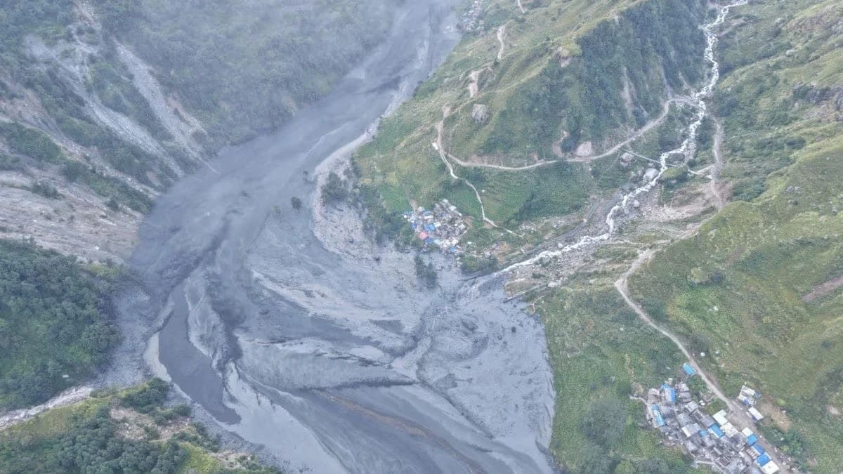
On Sunday, October 11, 2026, a flash flood tore down the Budhi Gandaki River in Nepal's Gorkha district. It swept away dozens of houses, at least four bridges and parts of hydropower sites, leaving at least five people missing. Nepal's disaster agency says more than 80 people, including nine foreigners, have been rescued. The flood came only weeks after the country's deadliest flooding in years. This guide explains which rivers are involved and why Himalayan valleys flood so suddenly.
Flood alerts went out after reports of flooding at about 6 AM local time. NDRRMA chief Dharam Raj Uprety said a dry landslide blocked the river, and the water behind it then burst through. Reports put the damage at roughly 35 to 45 houses, at least four bridges, two telecom towers, about 50 electricity poles and hydropower equipment. Nepal Army helicopters carried out rescues, and people along the downstream banks were told to evacuate.
The Budhi Gandaki rises in the high Himalaya near the Manaslu region and flows south through Gorkha. It is a tributary of the Trishuli River, part of the Trishuli-Narayani system. That is the same system hit by the Bhotekoshi flood on August 26, when a glacier collapse sent a catastrophic surge downstream. NDRRMA data cited in reports listed 1,451 bodies recovered and 5,745 people missing as of late September. In July 2025, another Bhotekoshi flood destroyed the Nepal-China Friendship Bridge. Downstream, these waters feed the Narayani, which flows on into India as the Gandak. This time, alerts covered Gorkha, Tanahun, Chitwan and the Nawalparasi districts.
In a narrow Himalayan valley, a large landslide can fall across a river and block it. Water builds up behind the debris and forms a temporary lake. These natural dams are loose piles of rock and soil. When the water rises high enough, it overtops or breaches the dam, and the stored water rushes downstream carrying boulders, trees and mud. Scientists call this a landslide lake outburst flood.
NBC News reported that the landslide blocked the Budhi Gandaki near the village of Chumchure before the dam gave way. The Kathmandu Post, citing hydrology officials, reported that the landslide may have happened a day earlier, on Saturday. Because the trigger is the failure of the dam, a flood like this can arrive with little warning, even when the weather is clear.
High in the mountains, meltwater collects in lakes held back by ice or loose rubble. If the wall fails, perhaps after an avalanche, heavy rain or a rockfall into the lake, a glacial lake outburst flood follows. A glacier or ice-and-rock mass can also collapse outright, as happened in August, sending water, ice and debris down the valley.
Nepal's rivers are especially exposed because they start in glaciated terrain and drop thousands of metres within a short distance, which gives floodwater enormous speed and force. ICIMOD, the Kathmandu-based mountain research centre, said this event highlights the range of hazards that can generate destructive floods in Himalayan river systems.
Nepal receives most of its rain between June and September. Intense rain can trigger landslides, swell rivers and cause flash floods directly. Rain also saturates slopes, which can weaken them long after a downpour ends, so a hillside may fail days or weeks later. October falls after the main monsoon, so this flood shows that hazards persist beyond the rainy season.
The Himalaya is geologically young, steep and still rising. Slopes are fractured by earthquakes, freeze-thaw cycles and erosion. Gorkha was the epicentre of the 2015 earthquake, which is widely reported to have destabilised many hillsides. In narrow gorges, even a modest landslide can dam an entire river.
Roads cut into hillsides, hydropower construction and homes built close to riverbanks increase both the risk and the damage. The latest flood damaged hydropower sites and a highway bridge linking Gorkha and Dhading, showing how infrastructure in river corridors can be exposed. This is a general observation about exposure, and no investigation into this specific event has been reported.
Warmer temperatures are shrinking glaciers and creating more glacial lakes, and changing rainfall patterns can make extreme events more intense. Scientists caution that individual events cannot be blamed on climate change alone, and the cause of this particular landslide has not been officially established. But the broader trend raises the odds of such hazards.
Water, mud and boulders move faster than people can run, and warning times can be minutes. Villages often sit on flat terraces beside the river, exactly where floods strike. Bridges and roads fail, cutting off rescue and relief, which is why helicopters were essential this time.
Was this a glacier flood?
No. Officials attributed it to a landslide that blocked the river and then burst, not to a glacial lake.
Is the danger over?
Not necessarily. Authorities continue search and rescue, and no further forecast was reported.
Based on reports from AFP, Al Jazeera, NBC News, Japan Times, dpa and Kathmandu Post as of October 12, 2026. Figures may change.