
Super Typhoon Champi Path Update: Jeju Island and South Korea on Alert

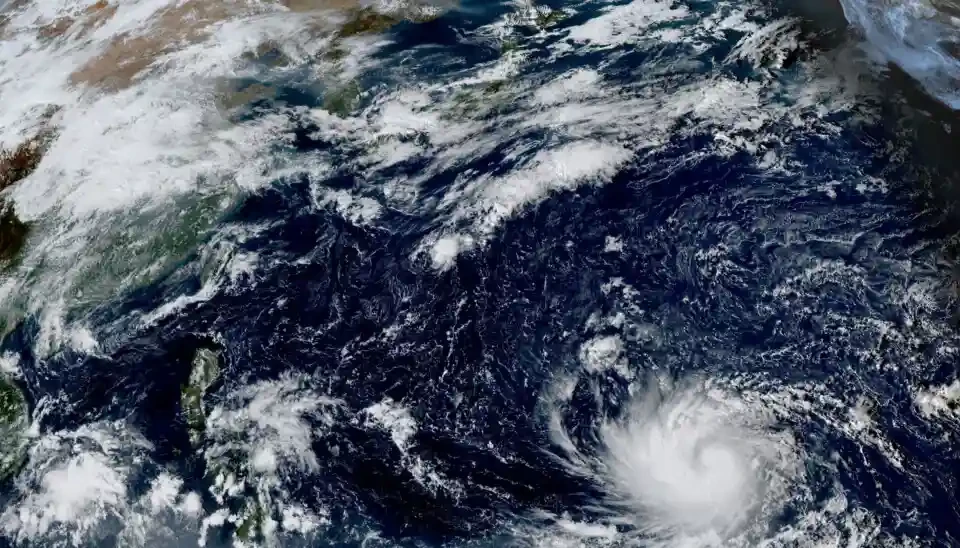
Super Typhoon Champi Changes Course, Raising Weather and Coastal Safety Concerns Near South Korea
Super Typhoon Champi Takes an Unexpected Turn
SEOUL, October 21, 2026 — Super Typhoon Champi has shifted from its earlier projected route, putting meteorologists across East Asia on alert as they assess whether the powerful tropical cyclone will move towards southern Japan, approach South Korea or follow an alternative path across the western Pacific.
Champi was passing south-southeast of Okinawa on Wednesday, with maximum sustained winds reported at approximately 209–212 km/h. The storm had previously been forecast to move northwest towards Taiwan before weakening and heading towards mainland China. More recent atmospheric changes have prompted forecasters to revise that outlook.
South Korea’s weather service projected that Champi could turn northeast after passing near Taiwan and approach Japan’s southern Kyushu region around October 26. Japan’s meteorological agency, however, indicated a route that could bring the system closer to Jeju Island and the waters around Tsushima. The US Joint Typhoon Warning Center also favoured a route towards southern Japan, while some forecast models continued to allow for a track towards China.
The differing projections underline how quickly a major typhoon’s path can change. Champi’s eventual route and its potential impact on South Korea remain uncertain, making further official updates particularly important. 
Why Has Champi’s Forecast Track Changed?
A key factor behind the revised forecast is a change in the high-pressure system influencing the storm’s movement.
Earlier projections indicated that a broad area of high pressure stretching across inland China towards Japan would help steer Champi westward. According to the weather analysis, that high-pressure area weakened more rapidly than expected, potentially opening a pathway for the typhoon to turn northeast.
Tropical cyclones are steered by large-scale atmospheric circulation, and changes in surrounding pressure systems can significantly alter their direction. Forecast models may respond differently to these evolving conditions, particularly when the storm is still far from the areas that could eventually be affected.
Although forecasters increasingly anticipated a northeastward turn, they had not reached a common conclusion about the cyclone’s route beyond Taiwan. A projected track towards Japan does not automatically rule out hazardous weather near South Korea, particularly around Jeju and nearby waters.
For residents, travellers and maritime operators, the most useful information will be the latest official forecast rather than any single projected path.
Jeju Issues Coastal Safety Advisory
Concern over strong winds and rough seas has already prompted authorities on Jeju Island to strengthen coastal safety measures.
Jeju Coast Guard announced a coastal accident risk advisory for October 21–23, covering a period when strong winds and high waves were expected around the island. Forecasts indicated winds of approximately 9–15 metres per second, with wave heights potentially reaching 3.5 metres.
Coast Guard teams planned to increase patrols along the shoreline and at sea, focusing on potentially dangerous locations such as breakwaters and rocky coastal areas. Officials also urged anglers, tourists and other people visiting the coast to follow weather updates, avoid exposed locations during deteriorating conditions and wear life jackets when appropriate. 
The advisory is a precaution against coastal accidents and does not, by itself, mean that Champi will make landfall on Jeju. Dangerous waves and strong winds can affect coastal areas even when a typhoon remains offshore.
Strong Winds and Rough Seas Pose Immediate Risks
Beyond the uncertainty surrounding Champi, South Korea was also facing a spell of unsettled and colder weather on October 21.
Forecasts warned that strong gusts could affect western coastal areas, Jeju, mountainous parts of Gangwon Province and the eastern coastline. Gusts could reach around 70 km/h or more in exposed areas, with even stronger winds possible in mountainous locations.
Rough seas were also expected across several offshore areas. Forecasts indicated waves of approximately 1.5–3.5 metres in a number of affected waters, with potentially higher waves in parts of the East Sea. These conditions can create risks for fishing vessels, passenger boats and other marine operations.
Authorities advised people to secure outdoor structures, exercise caution around falling objects and check transport information before travelling. Coastal visitors should avoid breakwaters, rocky shorelines and other places where waves can surge unexpectedly.
These hazards are important even if Champi ultimately tracks away from the Korean Peninsula.
Could Super Typhoon Champi Hit South Korea?
As of October 21, a direct impact on South Korea had not been confirmed. The main uncertainty concerned whether Champi would continue towards Japan’s southern islands or pass closer to Jeju and the southern Korean coastline.
The storm was forecast to weaken considerably as it moved northward. South Korea’s projection suggested that its maximum winds could fall to around 68–72 km/h by the time it approached waters near southern Japan or Jeju around October 26. However, forecasts several days ahead can change, and the storm’s future intensity and direction remained unsettled.
A weaker cyclone can still generate hazardous waves, strong gusts and disruption to marine transport. Its actual effects would depend on the final track, speed, size and surrounding weather systems.
People planning travel to Jeju, southern Japan or nearby coastal destinations should monitor official weather bulletins and check ferry and flight updates closer to departure.
What Residents and Travellers Should Do
While meteorologists refine the forecast, practical precautions can reduce exposure to coastal and weather-related hazards.
- Check official updates: Follow bulletins from the Korea Meteorological Administration and local authorities rather than relying on a single forecast graphic.
- Stay away from exposed coastlines: Avoid breakwaters, rocky shores and wave-washed areas during periods of strong wind and rough seas.
- Review marine and travel services: Fishing crews, boat operators and travellers should check for warnings, cancellations and schedule changes.
- Secure outdoor objects: Strong gusts can dislodge signs, loose equipment and other unsecured items.
- Follow local instructions: If authorities restrict access to a coastal area, comply with the advisory even if the typhoon’s centre remains far away.
What Happens Next?
The next stage of Champi’s development will depend on how the surrounding atmospheric circulation evolves and whether forecast models converge on a clearer route. Japan, South Korea and regional meteorological agencies are expected to continue tracking the storm as it moves through the western Pacific.
For now, the key distinction is between a possible future approach by Champi and the hazardous weather already forecast around coastal areas. Jeju’s safety advisory reflects the immediate risk from wind and waves, while the typhoon’s precise path remains open to revision.
Super Typhoon Champi has changed its projected course, with forecasts differing over its eventual movement towards Japan, Jeju or another part of the region. South Korea has not confirmed a direct hit, but strong winds and rough seas warrant caution. Residents and travellers should keep checking official updates as the October 26 forecast window approaches.